Up: Contents Previous: 1. INTRODUCTION Next: 3. PEOPLE OF THE BARRIO
2.1. History
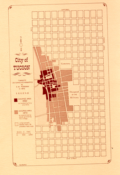
Fig. 2.1 - City of Tucson: 1862/72 (by Don Bufkin; reprinted from The Journal of Arizona History, vol. II, no. 3 (Autumn, 1970), published by the Arizona Historical Society.
The early business district of Tucson was concentrated between Broadway and Alameda, Main and Church Streets. This was then surrounded with residential blocks: Chinese shanties to the north and "El Barrio Libre" to the south. The general consensus is that the Barrio district as we know it today was substantially larger during the 19th Century. Today's Barrio is the southern portion of the earlier Barrio.
Main Street formed the geographical western limit of the Barrio. Located along Main Street were the homes of Governer McCormick, Peter Kitchen, the Drachmans, Oteros and other prominent Tucson families; to the west of this area were Carrillo's Gardens, containing Little Eye Springs and Simpson's Baths. These gardens were later called Elysian Grove, which contained a theatre, baseball park and other amusement features.
Existing evidence from various sources indicates that Main Street proper was not included in the "Free Neighborhood." The Tucson City Directory of 1881 notes that, "in 1881, Main, Pennington, Congress and Meyer Streets, and Stone, Toole and Osborne Avenues are among the most spacious and promising thoroughfares at the present..." The mention of Meyer as a "promising thoroughfare" suggest at least a partial social acceptance of the Barrio district at this time.
The Barrio most likely consisted of the area lying immediately to the east of Main Street, between Jackson and Simpson Streets. The following contemporaneous quote illustrates the physical character of the Barrio's street patterns: "...it yet retains many of the peculiar features of a Spanish-American town... the division known as the Barrio Libre, with its tortuous lanes and alleys, its uninviting adobes with their cool, roomy courtyards in the interiors, its motley population of Mexicans and Indians, and the mellifluous chatter of la lengua oastellana, looks a bit of old Mexico transplanted to the Northern Republic."1 In 1881, however, many of the streets of today's Barrio were considered to be among the principal streets of Tucson 2.
By 1914, Broadway, between Meyer and Church Streets, was almost totally residential and formed the northern limit of the Barrio. There was a noticeable increase in Broadway residents with Spanish surnames and a diminishing number of Anglo names.
In 1881, the City Directory had the following to say about the Barrio Libre:
"This designation was given by the Mexican residents to that quarter of the city lying among Meyer and adjacent streets, southward of the business portion of the city occupied by the Americans. It means Free Zone, and in earlier times was allowed to remain without legal restraints or the presence of a policeman. Here, the Mescalian could imbibe his fill, and either male or female could, in peaceful intoxication, sleep on the sidewalk or in the middle of the streets, with all their ancient rights respected. Fandangoes, monte, chicken fights, broils, and all the amusements of the lower class of Mexicans were, in this quarter, indulged in without restraint; and to this day much of the old-time regime prevails, although the encroachments of the American element indicate the ultimate doom of the customs in the Barrio Libre. It must be understood that these remarks apply only to the lower class of Mexicans and not to the cultured Mexican residents of the city, who, for intelligence and enterprise, are foremost among our people."
An important phrase in the above quote is, "earlier times." In other words, by 1881, the Barrio was not considered uncivilized. It seems that in 1881 this area and its unique 'customs' were already being given more than passing consideration. Ninety years ago an awareness apparently existed of the, "encroachment of the American element;" yet today (1971) there is no significant evidence to indicate that a substantial change in the character of the Barrio, as anticipated in 1881, has taken place.
A birdseye photograph of Tucson taken from the top of Sentinel Peak ("A" Mountain) about 1882 (Fig.2.12) shows a substantial amount of development beyond the southern edge of the built-up portion of the city as recorded on the Sanborn Fire Insurance Map of 1886 (Fig. 2.2). The photo reveals structures south of Cushing (14th) to about 18th Street and between Stone and Main. A scattering of adobe houses is evident throughout the area. Basically, the area recorded in the photograph is the Barrio Libre district as defined today. A 'free district' such as the Barrio Libre, outside the city's tight control, was a very important element in a city complex. To be without this 'immunity' would be comparable to having justice without liberty.
This sequence of maps (Figs. 2.2 to 2.6) shows the built up portion of the study area as recorded by the Sanborn Company from 1886 to the present. In their original form, the Sanborn Maps reveal plans of buildings according to materials of construction and note the functions contained. Prominent structures are labeled, and other information vital to insurance records is recorded. The maps are remarkably accurate as to the configuration of the buildings and their location on the site.
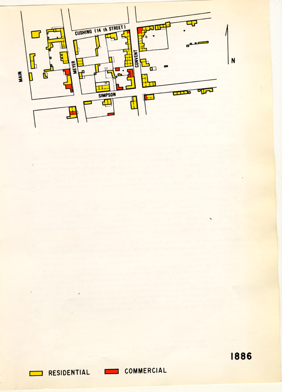
Fig. 2.2 - Sanborn Map - 1886. Fire insurance map of the study area in 1886.
Some individuals associated with the Barrio merit attention, but one specific person is of importance because of his role as an Arizona pioneer, Pete Kitchen, the "Daniel Boone of Arizona;" the only connection between savagery and civilization for many years in southern Arizona. A portion of his last home still remains in the Barrio.
"Pete Kitchen had amiable moods and yet could be as cold and hard as steel. He fought the Apaches and Mexican desperados in a one-man battle, while the other farmers and ranchers had left the southern valleys and mountains. Pete Kitchen was the only settler whom the Apaches could not dislodge. His name struck terror to every Apache's heart."3 A prominent farmer and rancher in southern Arizona, Kitchen owned a thousand acre ranch north of Nogales, Arizona, where he raised crops and reared cattle and hogs. Before the advent of the railroad, he was a supplier of high quality produce and meats to Tucson merchants. With increased competition, Kitchen sold his ranch and moved to Tucson about 1880. He spent the rest of his life in his home on South Main Street. Pete Kitchen was the type of man who pioneered Arizona following the Gadsden Purchase.
Research at the Pioneer Land and Title Company links Pete Kitchen to a piece of property in the Barrio Libre area, specifically Block No. 228, Lot No. 144.4 The records are unclear as to the exact date Kitchen acquired the property, but available evidence suggests the period between 1872 and 1880. The property was morgaged to A.P.K. Safford, et al, by Kitchen in 1881. As the appearance of the railroad in 1880 resulted in the decline of Pete Kitchen's ham business, it would appear that he arrived in Tucson shortly after 1880.
In seeking to locate his final residence, we studied the records at the Pima County Assessor's Office, and established 361 S. Main as the present address of the remnants of Kitchen's home. The Pioneer Land and Title Company associated 321 S. Main with Kitchen; however, further investigation revealed that the Tucson street addressing system was changed between 1892 and 1915; the exact date not determined.
With respect to the house itself, the Sentinel Peak photograph of 1882 shows that it was constructed in the traditional Spanish/Mexican style, complete with zaguan. However, the structure existing on that property today is constructed of 5" and 9" brick walls. The possibility of Kitchen's house being built of brick is not unreasonable, for brick was in use in Tucson before 1880; yet the possibility of the present building being Kitchen's house is very slim. The orientation of Kitchen's home was north-south, while that of the present structure is east-west, and the latter conveys no visual resemblance to the house in the 1882 photograph. A reasonable assumption would be that if any elements do remain from Kitchen's house, they are only fragments and do not substantially contribute to the existing building, which was probably built at a later date.
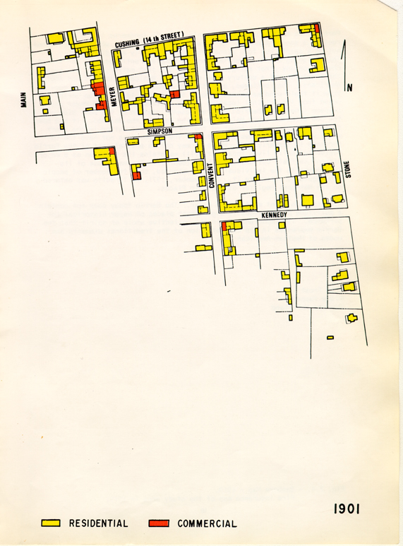
Fig. 2.3 - Sanborn Map - 1901. Fire insurance map of the study area in 1901.
Perhaps the most unusual of Tucson's historic landmarks is the Mexican religious shrine known as "El Tiradito" (The Outcast), which is dedicated not to a saint, but to a sinner who died violently and dishonorably. This "Wishing Shrine," manifesting the complete antithesis of San Augustin Church, or any other religious edifice, for that matter, has, for over three-quarters of a century been revered by Mexicans, Indians and Anglo-Americans. They believed, and still do, that their wishes would come true if their candles burned through the night. In 1928, the Shrine was moved from its original location on the southwest corner of Meyer and Simpson (the inner Barrio) to its present location on the west side of the 300 block of South Main Street (the edge of the Barrio). It has been stated that the mystic power of the Shrine did not suffer in the short move, yet our interviews suggest that the Shrine does not have the importance it formerly had. While it may not be a vital part of the Barrio residents' daily lives today, it still maintains its position as a major element in their culture and ethnic identity. The magnitude of its importance to the individual has not changed, only the number of people who regularly patronize it. In November, 1971, El Tiradito was entered on the National Register of Historic Places.
Finally, one point must remain clear. The Barrio today does not contain a multitude of individually significant places of major historical importance. Its importance is in the collective whole or spirit that the Barrio expresses in its demonatration of the traditional elements and modes of Mexican-American life.
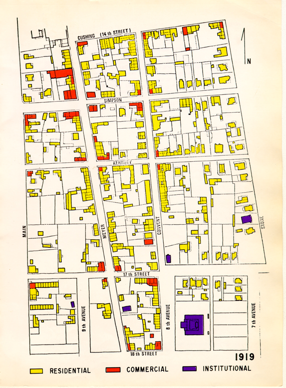
Fig. 2.4 - Sanborn Map - 1919. Fire insurance map of the study area in 1919.
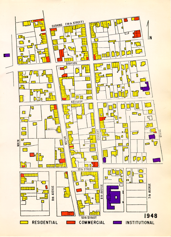
Fig. 2.5 - Sanborn Map - 1948. Fire insurance map of the study area in 1948.
UNIVERSITY OF ARIZONA:
- Dr. Allen Kite - Anthropology. Versed in the cultural and sociological aspects; specifically, Indian, Mexican, and Mexican-American.
- Dr. Lay James Gibson - Geography.
- Dr. Thomas Saarinen - Geography. Working in conjuction with Dr. Gibson gathering data to be made into a book which will contain information pertaining to the Barrio Libre.
- Dr. James Officer - Coordinator of Internal Programs. Wrote his thesis on Mexican-Americanheritage in the Southwest.
- Mr. James Ayres - Associate Archeologist with the Arizona State Museum. Conducted detailed research of that portion of the Barrio which was destroyed to accommodate the new convention center.
- Professor Bernard Fontana - Anthropology. Presently a member of a newly formed Historical Committee which plans to conduct research in the Barrio Libre area.
- Dr. Edward Spicer - Anthropology. Has done extensive study on the Yaquis influence in Tucson.
CITY PERSONNEL:
- Mr. Chris Helms - Public Relations, Tucson Chamber of Commerce. Associated with many people, committees, and organizations in Tucson and is able to direct persons to reliable information sources.
- Mr. Don Bufkin - Tucson Area Transportation Planning Agency (TATPA)
- Mr. Phil Whitmore - Urban Renewal.
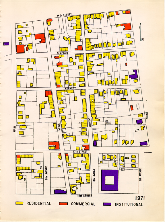
Fig. 2.6 - Sanborn Map - 1971. The study area as it exists at present, updated from the 1948 map.
OTHER SOURCES:
- Mr. Thomas Peterson - Arizona Historical Society.
- Mr. Sid Brinckerhoff - Arizona Historical Society.
- Has available books, old newspapers, past city directories, Sanborn Maps, and various personal documents which pertain to the Barrio.
- Mr. Edward Herreras - Architect.
- Currently restoring and rehabilitating certain old structures located in the Barrio Libre area.
- Father Kieran McCarty, OFM - San Xavier Mission. An expert on Mission Architecture in Southern Arizona and head of a new historical committee which plans to work in the Barrio.
- Mr. Steve Ochoa - Tucson Resident. A man interested in the history of Tucson.
LITERATURE:
- Thesis - Dr. James Officer.
- Thesis - Adrienne Barbara Anderson.
- Tucson by Bernice Cosulich.
- Life in Old Tucson
- by Frank C. Lockwood.
- Old Tucson Newspapers.
- Past City Directories.
- Sanborn Maps.

Fig. 2.7 - Meyer Street photographic sequence: View 1. Looking north up S. Meyer Street from between W. 17th and Kennedy Streets, showing "angled" corner store of "Dan Won & Co." at northwest corner of Meyer and Kennedy Streets. Taken after 1884 (note electric "moonlight" over intersection).
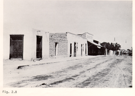
Fig. 2.8 - Meyer Street photographic sequence: View 2. Looking northwest from intersection of W. Kennedy up Meyer Street, showing "Don Kim New Store" just to right of center of photo, with large shadow cast by entrance "toldo." A row of five trees can be seen on west side of Meyer Street just north of Don Kim Store. This view was probably taken at about the same date as View 1.
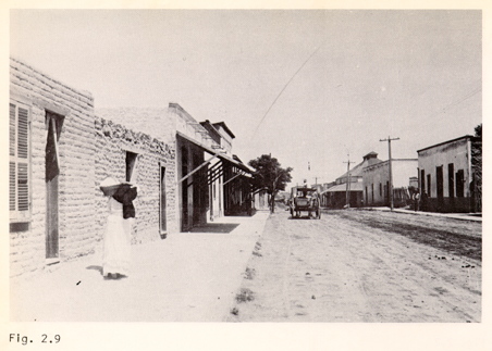
Fig. 2.9 - Meyer Street photographic sequence: View 3. Looking north from northwest corner of Simpson and Meyer Streets; note large sloping roof with monitor-type ventilator and entrance "toldo" of General Store and Saloon located at the northeast corner of Cushing (now 14th) and Meyer Streets. Probably taken in a later year than Views 1 and 2: note addition of new "toldo" to street facade of third building up on left-hand side of Meyer Street and higher trees. (There now appear to be only four trees left.)
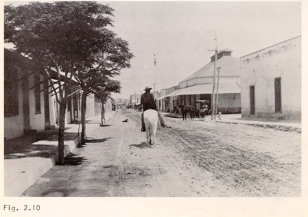
Fig. 2.10 - Meyer Street photographic sequence: View 4. Looking north from between W. Kennedy and Cushing Streets. Note electric "moonlight" over Cushing Street intersection and placement of trees in street just beyond curb line. Probably taken same date as View 3.
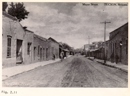
Fig. 2.11 - Meyer Street photographic sequence: View 5. Looking north from between W. Cushing and McCormick Streets. Taken in 1905. All five photographs of sequence were found in the collections of the Arizona Historical Society.
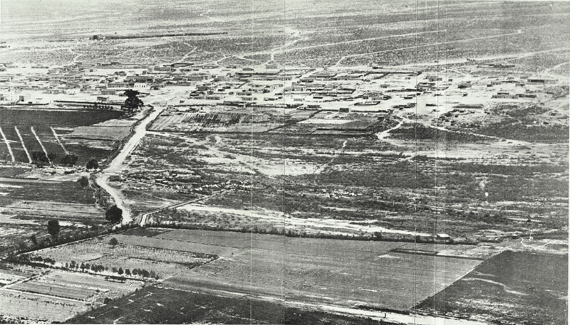
Fig. 2.12 - Aerial photograph taken from Sentinel Peak ("A" Mountain), showing the Barrio in 1882. This photograph reveals many more structures in the southernmost portion of the study area than are recorded in the 1886 Sanborn Fire Insurance Map (Fig. 2.2.).
2.2. Architectural History
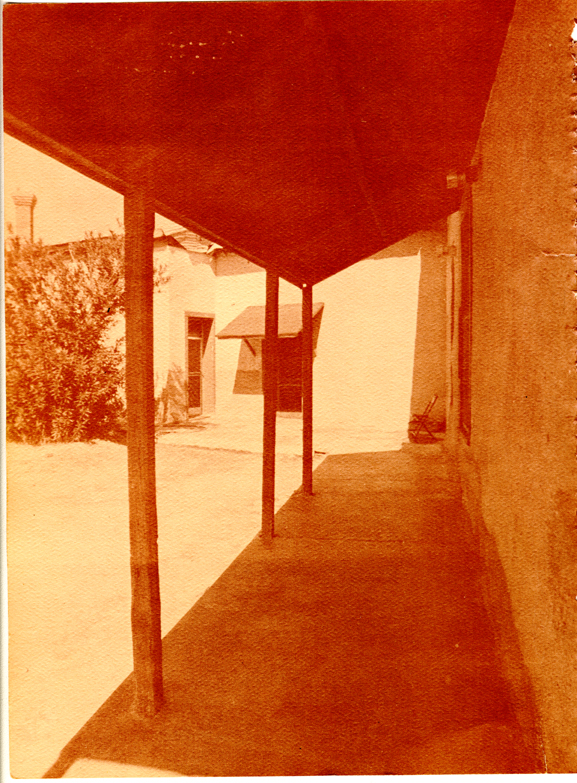
Fig. 2.13 - Toldo: a light-weight (timber) canopy attached to adobe walls, at times partly supported by timber posts (as here) used to provide solar shading and rain protection, usually over windows and entrance doors along public street facades, or (as here) along walls facing rear patios or garden areas.
Although Indian cultures existed along the Santa Cruz River Basin over one thousand years ago, Tucson's contemporary architectural forms can be traced back only as far as the arrival of the first Spanish missionaries. Much was derived, however, from the Indians' long experience in the use of available indigenous building materials and from the unique means they developed to shelter themselves from the harsh environment.
The northernmost example of the ancient Mexican culture and architecture is located in the ancient city of La Quemeda, 200 miles northwest of Mexico City. This city was abandoned long before the arrival of the Spanish in 1535. The arid climate has well preserved this fortified city. The walls are of mud adobe resting on stone retaining walls; one specific structure had stone slab columns enabling the builders to break away from the previously dark, narrow structures permitting larger more open interior spaces.
The pueblo structures of Arizona and New Mexico are indicative of the more permanent settlements and of a more advanced building system and architecture in the area. The period of classic Pueblo development falls between 1100-1300 A.D. The Pueblo Indians evolved a type of cluster housing related to a linear street organization. The units were arranged around courtyards with a north-south orientation. On a community level, a large communal open space called a "Kiva," was the center. Examples of this classic type can be found in Pueblo Bonito and in Acoma, New Mexico. After 1300 A.D., the Pueblo tribes began moving back to the cliffs where they originally had lived (c. 1 A.D.). Examples of the newer cliff dwellings can be found in Mesa Verde and Durango, Colorado and also in Canyon De Chelly in northern Arizona. It appears coincidental that the Pueblo courtyard housing schemes and their plaza-like "Kivas" closely parallel the Spanish community developments, although the Pueblo and Spanish styles developed independently of one another.
Fig. 2.13. - Toldo: a light-weight (timber) canopy attached to adobe walls, at times partly supported by timber posts (as here) used to provide solar shading and rain protection, usually over windows and entrance doors along public street facades, or (as here) along walls facing rear patios or garden areas.
Around 1700, the first Spanish missionaries and explorers began arriving in the Tucson area. The missionaries were the only Spanish interested in creating any permanent type of settlement. They were not well trained in their mother country's architectural styles, and that, combined with the use of untrained Indian labor, produced a very curious mix of styles. The missionaries were primarily interested in establishing the Church in the southwest with its impressive monumental forms. Domestic structures were of secondary interest, if at all.
Local conditions, climate, defense, scarce building materials, and a simple building technology allowed only a limited application of "pure" Spanish architecture in the isolated Mexican village of Tucson. Due to a lack of skilled craftsmen, the execution of the Spanish influenced architecture was rather crude and was naturally intermixed with the Indian vernacular. As Gowans expresses it:
"It meant building as they did not architecture in the proper sense of man's organizing or controlling an environment to suit his material and psychological needs, but more like birds placing a nest...caves and wigwams taking form far less from human will and pleasure than at the dictates of nature...it meant reliving, however briefly, those long ages of pre-history when nature, not man, was in command...that 'art' was one thing and life another."5
The basic living unit was constructed with raw adobe walls approximately two feet thick. The roof was supported by rough wooden beams upon which were laid ocotillo or saguaro ribs, which, in turn, were covered with dirt. This assemblage was slightly sloped so that rain water from the roof would drain through wooden canales extending through the parapet wall. Water was thus prevented from running down the exterior and consequently washing away the vulnerable adobe. Doors were recessed into the interior surfaces of the thick adobe walls, while windows were placed flush with exterior wall surfaces so as to provide room for opening the inswinging windows and to provide a small window seat or shelf.
Room sizes were determined by the length of the beams available (usually between 10-15 feet). Openings (windows, doors, etc. ) were limited in size by the weight of the adobe and the low bearing and spanning capabilities of the timber lintels and were invariably located at or near the center of wall surfaces in order to leave corners intact for maximum structural strength. The combination of thick structure (walls, roof) and high density material provided these buildings with a high degree of thermal capacity. This, in turn, provided relatively even indoor temperatures closely approaching average outdoor temperature and delayed for up to six or eight hours the impact of the large diurnal temperature swings characteristic of the desert. With the exception of late summer nights, these buildings were usually able to provide a comfortable indoor thermal environment without mechanical aid.
Row houses were quite common in early Tucson, and the residences of the more affluent citizens featured a central "zaguan" or entrance hall. (Fig. 2.18) The zaguan was a rather large room, perhaps 12 feet wide, 20 feet long and 16 feet high. It had openings at either end; one opened into the street, the other onto a private backyard. The zaguan also acted as a link to various side rooms; usually the parlor on one side and dining and/or kitchen areas on the other. There were no interior halls in the zaguan-type houses; the rooms that weren't directly linked to the zaguan had to be reached by walking through other rooms or by walking outside under the cover of a "toldo."
Various types of light-weight (timber, sahuaro ribs or ocotillo ) shading canopies were employed in a variety of ways during the Spanish/Mexican period, including toldos (attached to a structure) and ramadas (free-standing). Sloping timber toldos supported on angled metal brackets or timber columns were customarily used, particularly in the Barrio, to create cooling shade and summer rain shelter over windows and entrance doorways along the public street, as seen in early photographs of Meyer Street. (See Figs. 2.7 to 2.11) Toldos were also located along walls facing rear patios or garden areas, and their use ranged from shady sitting areas or walkways to sleeping areas in hot weather to cooking centers, etc. (See Fig. 2.13) Toldos were also used to provide shelter over cooking areas toward the rear of the house. With the introduction of modern kitchen facilities and a corresponding decline in the need for domestic help, these cooking porches were often enclosed as interior kitchens.
While the zaguan was a fairly common element, other rooms of the house were linked to form a rectangular 'L' or 'U' shaped house plan. Generally, the house was zoned in a sequence from public to private, with the entrance occurring off the public street. One entered through the anonymous street facade into the zaguan, which, in turn, led into the living areas or into the private courtyard. This form of residence was most probably imported from Spain via Mexico, with the normal amount of alteration being allowed for by the cultural and environmental differences between Spain and Mexico. Simpler row houses often repeated this type of zoning, with living spaces toward the public street, followed by sleeping spaces and spaces for cooking and dining toward the rear yards or patios.
With respect to town planning, the Spanish missionaries and administrators brought with them direct translations of their own home towns and colonies. Old Spain strongly enforced a highly prototypical town plan consisting of a rectangular grid system arranged around a central plaza (Law of the Indies). This plaza contained the church and a park. Urban domestic units were arranged contiguously around the perimeter of the block with little or no setbacks. The central area of the block was left vacant and served as a communal and private area for inter-family communication (often blood relatives lived on the same block). This area was also used for gardens, laundry yards, controlled children's play and for defense.
Tucson, as previously mentioned, was an isolated settlement far north of Spain's Mexican colony. It was, therefore, not directly exposed to the purest interpretations of Spanish town planning. Tucson was definitely a rugged and crude frontier town, not an elegant commercial center such as
found in the midwest or west coast. While based on a rough sort of grid-type layout, many early Tucson streets met at other than right angles and offered a unique character to the streets and pedestrian walkways. The central plaza concept was also altered and replaced with many plazas: La Plaza Militar, the Plazas De Las Armas, De Las Mesilla, Plazuela, and the Spanish Presidio.Tucson actually began in 1776 as a small Spanish presidio 700 feet square, with approximately 150 soldiers. By 1830, it had grown into a medium sized Mexican village with a population of 8,000. During this period, the village had changed little except for growing beyond the original presidio walls. It was still a small town, primarily composed of one-story, one-room adobe houses with dirt floors. They contained few windows or doors, and their fronts were flush with the street, presenting a very regular, unadorned and often austere street facade. They reflected few of the refinements found in Mexican buildings further south but were of the same spirit as the Sonoran examples found in such towns as Magdelena. This is not surprising, since it was from Sonora that the Mexican ancestors came.
The first Americans began to enter the area in 1854, the year of the Gadsden Purchase, but it was another decade before a significant Anglo population existed in Tucson. Arizona became a territory in 1863, and trade with the States began around 1862. By 1877, Tucson was incorporated as a city, yet there was very little change in its image or building construction technique. Even the wealthy Anglos, such as Messrs. N. Fish and H. Stevens, built in the existing vernacular style. Few of the buildings were finished in plaster; the city had unpaved, unlit streets, no electricity, no sidewalks, and no public works, but all were imminent. For a while the Civil War halted immigration, but afterwards it picked up immediately.
The year 1880 marked the beginning of a big change for this Mexican village. The railroad came to Tucson; the indian wars were over, and mines opened. There was more trade with the east and west. New immigrants came, bringing money, a new labor force, industry, and the latest American architectural style--Victorian. This style was popular for those wishing to emulate the 'house back home.'
The Victorian era brought two important changes--materials of construction and land-use patterns. Wood frame constructions was favored by the Anglos in the late 1870's because houses would cool down faster than the dense thickness of the adobe walls would allow. Burnt brick construction followed a short time later. Reference is made to a two-story brick building constructed in 1869 and another in 1879 (Tucson Citizen, Oct. 24, 1879). The latter was constructed of brick imported from Phoenix. (The first reference to locally made brick was not until 1883-84.) The wood frame and brick construction allowed greater flexibility in construction. Two-story structures, relatively uncommon in adobe construction, began to dot the city's skyline.
Detached houses with landscaped yards to the front, side and rear were being built along the broad avenues. Houses had sloping, hipped, pyra-
mid and gabled roofs covered with tin, wood shingles or asphalt. The buildings were in sharp contrast to those of the Spanish/Mexican period and attested to the wealth and status of the Anglo. The published Victorian catalogues had a tremendous effect on the architecture of Tucson. The theories of the Victorian style coincided with the attitudes of the young territory. Victorian architecture presented an ornamental approach to architecture and became quite eclectic in its application of details. Decoration made utilitarian things beautiful with no connection between form and function. Tucson was introduced to the concept of mass-produced ornament, which was inexpensive and easy to use and could be applied to the existing adobe and brick structures in the city. Existing buildings were transformed into the "latest" architectural idioms, reminiscent of the familiar architecture back home.The last decades of the 19th Century saw more activity in growing Tucson. The railroad was completed in 1881; telephones were introduced in that same year; and electric street illumination was provided in 1884 with the installation of 'moon lights' suspended over city intersections. More public works projects were under way, and a university was under construction. When Arizona became a state in 1912, Tucson had a population of 15,000.
The preceding information on Tucson's architectural development relates directly to the "Barrio". This area is one of the very few remaining sections of the city which includes both the earlier Spanish/Mexican style (simple, flush-fronted contiguous adobe buildings) and the later, low-key Victorian (additive and adorned, but much less pretentious than in other parts of the city). While excellent examples of 'workers' housing' in both styles exist in the Barrio, it should be emphasized that it was composed predominantly of the Spanish/Mexican building style, with examples of Victorian architecture to be found on the eastern side of the study area. The Barrio remains as the city's oldest built-up district displaying the architecture of its earliest days. Its sole existence is justification for its preservation as an indication of early Tucson.
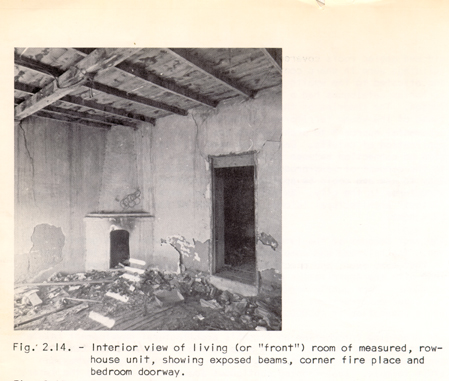
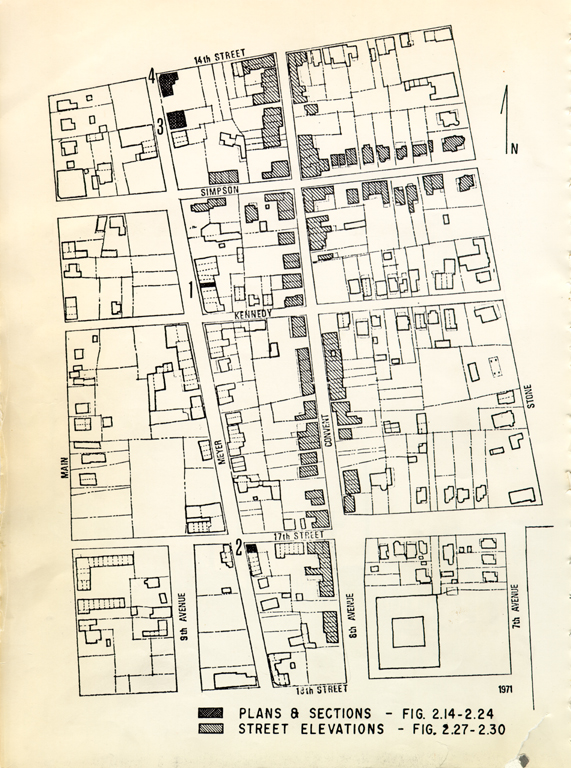
Fig. 2.14. - Interior view of living (or "front") room of measured, rowhouse unit, showing exposed beams, corner fire place and bedroom doorway.
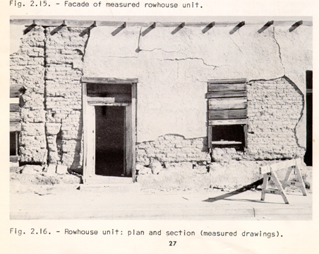
Fig. 2.15 - Facade of measured rowhouse unit.
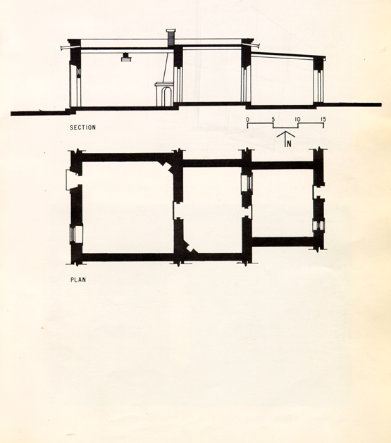
Fig. 2.16 - Rowhouse unit: plan and section (measured drawings).
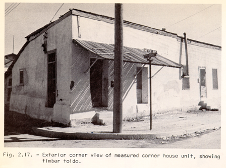
Fig. 2.17 - Exterior corner view of measured corner house unit, showing timber toldo.
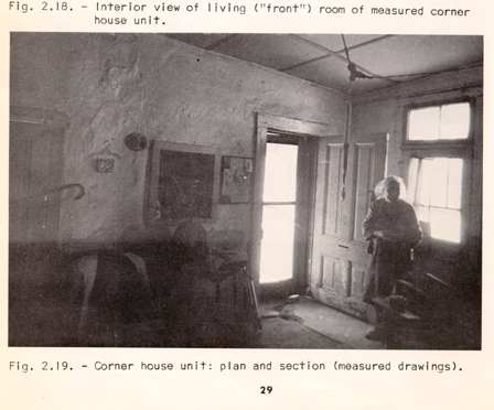
Fig. 2.18 - Interior view of living ("front") room of measured corner house unit.
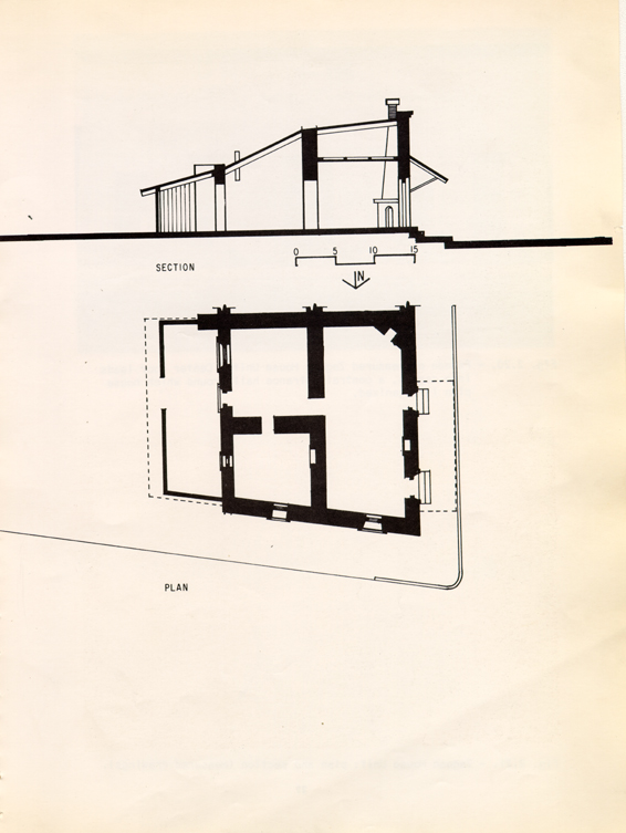
Fig. 2.19 - Corner house unit: plan and section (measured drawings).
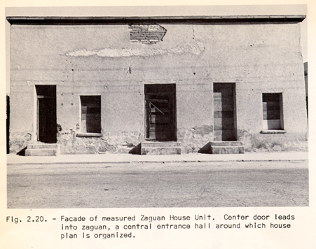
Fig. 2.20 - Facade of measured Zaguan House Unit. Center door leads into zaguan, a central entrance hall around which house plan is organized.
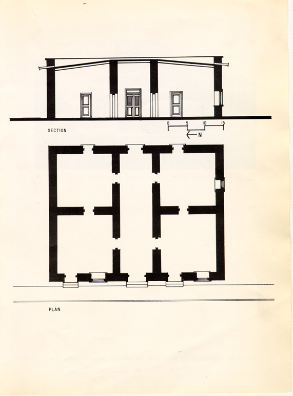
Fig. 2.21. - Zaguan House Unit: plan and section (measured drawings).
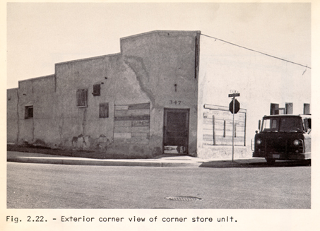
Fig. 2.22 - Exterior corner view of corner store unit.
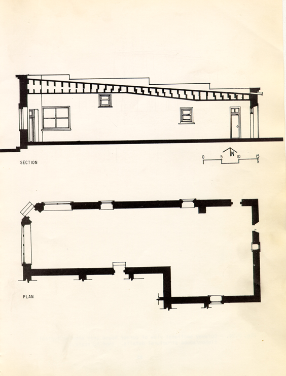
Fig. 2.23 - Corner store unit: plan and section (measured drawings).
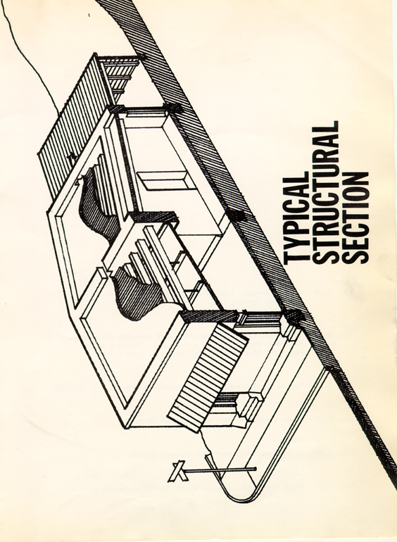
Fig. 2.24 - Cutaway sectional view of corner house unit showing typical timber/adobe structural details. (Not to scale.)
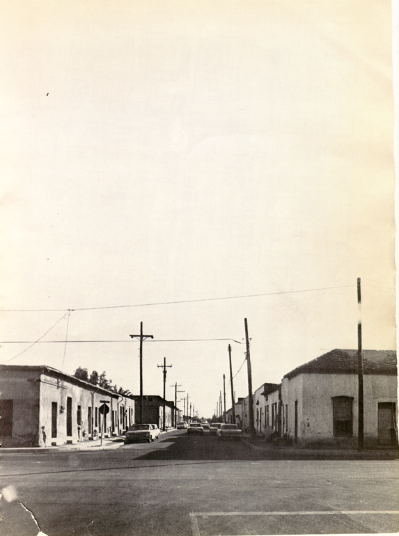
Fig. 2.25 - Convent Street, looking south from 14th Street and the Community Center.
Notes
1. P. Hamilton, Descriptions of Tucson, (1884 Ed.) p.67.
2. "...principal streets immediately south of Pennington and running parallel therewith, are Congress, Mesilla, Camp, Jackson, Ochoa, McCormick, Cushing, Simpson and Kennedy. Those immediately north of Pennington and running parallel therewith are Alameda, Washington Council and Franklin. Those east of Main Street are Meyer, Court, Church, Convent, Stone Avenue, 6th Avenue and Toole Avenue."
3. Bernice Cosulich, Tucson, 1943.
4. Appendix #2.
5. A. Gowans, Images of American Living (1964), p. 4.